|
Battle of Gadebusch in 1712
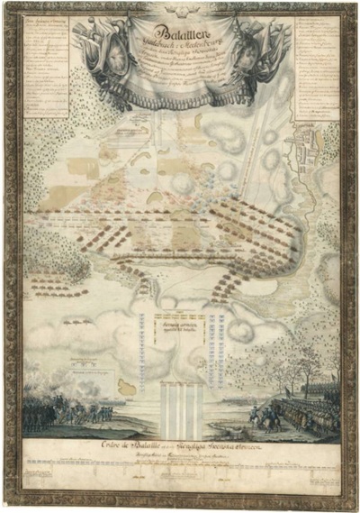
This map is
kept in the Swedish War Archive and was drawn by Quartermaster General
Magnus Rommel who participated in Magnus Stenbock's campaign. The map
clearly shows that the Swedish infantry now had turnbacks, which they did
not have in battle paintings of the battles of Narva and Düna. Below is a
translation of the War Archive's text description:
"Battle
at Gadebusch in Mecklenburg, between the Royal Swedish Army, under His
Excellence, Royal Councillor and Field Marshal...".
a) Terrain
Gadebusch-Pokrent-Radegast. Danish army camp at Gadebusch, west of the town
on the night of 9 Dec. General von. Scholten's first formation west of
Wakenstädt on the 9th. Danish army's second formation at Wakenstädt. Field
Marshal Flemming's advance behind the wings of the Danish army. Magnus
Stenbock's approach,. march (in detail) 2.5 km south of Gadebusch, attack (troop
units in detail) and pursuit in the direction of Radegast and camp there.
after the battle. The flight of the Danish-Saxon army over Radegast. Legend.
b) Bottom: on the right Swedish
cavalry during the advance and battle, on the left cavalry during firing,
and infantry during the advance and battle. The figures carefully drawn and
coloured. Bottom: Stenbock's. ordre de bataille on 9 Dec 1712. Rich
ornamentation, partly in the text.
[SE/KrA/0425/13/014]
|